

Fire Management
Successful Deployment Ignition Spheres
hectares successfully burned for fuel reduction
Litres per minute flow rate of ignited combustible mix

TDS “Vhagar” Drone
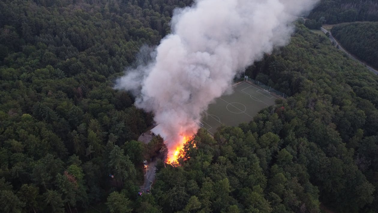
Fuel Reduction Burning
Our Aerial Drip Torch and Incendiary Drones remotely execute targeted fuel reduction burns in vulnerable land areas to reduce the risk of bushfire disaster. We collaborate with ground crews to quickly map proposed areas before burning, identifying potential hotspots.
We then deploy either our “Ignis” or Aerial Drip Torch Drone to precisely target areas prone to wildfires. Our method is not only safer but also protects local species and vegetation, reducing environmental damage.
Drone Features
Advanced Mapping Capabilities
We use advanced mapping to assess areas before controlled burns, accurately evaluating risks to local flora and fauna.
By mapping terrain and vegetation beforehand, we ensure precise and environmentally considerate operations. This approach enhances safety during burns and promotes responsible land management, preserving biodiversity and ecological balance.
Thermal Imaging
We use advanced thermal imaging to identify hotspots after controlled burns. By detecting elevated temperatures, we assess burn effectiveness and monitor re-ignition risks.
This data helps us quickly mitigate fire threats and aid ecosystem recovery. Thermal imaging improves burn assessment and supports sustainable land management.
Ignis Drone
We drop a payload of ping-pong ball-sized ignition spheres filled with potassium permanganate. Before being dropped to the ground, individual spheres are injected with ethylene glycol starting a chemical reaction that causes them to ignite some 30-40 seconds later.
Vhagar
‘Vhagar’ TDS’ Custom Aerial Drip Torch Drone can complement the Ignis or operate independently. This innovative drone is equipped to remotely release a flammable liquid, which ignites immediately.
This capability allows for controlled and targeted ignition of areas that require a hotter flame, aiding in controlled burns, fire management, and vegetation control efforts.
FREQUENTLY ASKED QUESTIONS
What is the max flight time?
Vhagar has a maximum flight time of 1 hour without payload and 30 minutes with full payload.
What is the capacity of the drone and flow rate?
Vhagar holds up to 20 litres of liquid napalm and releases it at a flow rate of 7-8 litres per minute, ensuring efficient and rapid ignition upon ground impact.
This can also be adapted to client needs.
Why would I need a drip torch drone over ignis balls?
Vhagar allows for burning in unfavorable conditions in shoulder seasons and allows to burn denser fuels that the balls can’t ignite.
TRUSTED BY BUSINESSES & ORGANISATIONS


FIRE FORESIGHT
XPRIZE Wildfire - Autonomous Fire Response
TDS is proud to be part of Fire Foresight, a global joint venture selected as one of 15 semifinalists in the $11M XPRIZE Wildfire Autonomous Challenge.
Our wildfire management solution is a rapid-response system — first, an autonomous drone is deployed to assess the threat level once smoke is detected. If the spotfire is deemed dangerous, a second suppression drone is sent to extinguish it. TDS drones are engineered to operate beyond visual line of sight (BVLOS) in complex terrains and adverse weather conditions.
FIRE FORESIGHT SYSTEM
Satellite Fire Risk Mapping
Our Fire Foresight platform leverages satellite data processing to map fire risk areas in near-real-time, powered by edge computing software from our partner Little Place Labs. This provides critical intelligence to emergency responders before a fire starts.
AI-Powered Fire Detection
Machine vision technology from our partner Robotics Cats identifies early-stage fires using AI-powered image recognition, enabling faster detection than traditional methods.
Autonomous Suppression Drones
TDS provides the autonomous suppression capability using custom-built drone swarms that can operate in extreme terrains. Our drones deploy water payloads directly onto spot fires, containing them before they spread.
Real-Time Command Platform
All subsystems are connected via private 5G networks with encrypted, real-time data exchange. Our partner Indicium Dynamics provides the data orchestration layer that generates actionable insights for emergency responders.
FIRE FORESIGHT x TDS
Drone-in-a-Box for Early Wildfire Detection
TDS Drone-in-a-Box (DIAB), in partnership with Fire Foresight, delivers an autonomous early detection and rapid response system for wildfires. Our self-contained drone stations are deployed in high-risk bushland, plantation boundaries, and national park perimeters — launching thermal surveillance flights at the first sign of smoke or heat anomaly.
Coupled with Fire Foresight’s satellite fire risk mapping, AI-powered smoke detection, and real-time command platform, the TDS DIAB system provides a complete detect-assess-suppress pipeline. When a fire is detected, the drone-in-a-box autonomously deploys to confirm the threat, map the fire perimeter, and relay live intelligence to emergency responders.
DIAB + FIRE FORESIGHT
Autonomous Early Fire Detection
The drone-in-a-box launches scheduled thermal surveillance patrols across fire-prone areas. Integrated with Fire Foresight’s AI smoke detection algorithms, the system identifies spot fires and hotspots within minutes of ignition — dramatically faster than traditional fire towers or satellite monitoring. Alerts are pushed directly to fire management operations centres.
Thermal & LIDAR Fire Intelligence
Radiometric thermal cameras map fire perimeters, rate-of-spread, and residual hotspots in real-time. LIDAR payloads scan fuel loads and terrain to support fire behaviour modelling. Post-burn, the drone-in-a-box monitors for re-ignition, providing ground crews with continuous intelligence for containment and mop-up operations.
Integration with Fire Foresight Platform
TDS drones feed live thermal and visual data into the Fire Foresight command platform via private 5G networks. Satellite fire risk mapping from Little Place Labs, combined with Robotics Cats’ machine vision, creates a layered detection system where our DIAB provides the rapid-response aerial confirmation and suppression capability.
CASA-Certified Drone Training for Fire Services
TDS provides CASA-certified Remote Pilot Licence (RePL) training tailored to fire and emergency services. We train your crew to safely operate drones for fire monitoring, mapping, and situational awareness — building in-house capability for rapid deployment during fire season. Our courses cover regulatory compliance, mission planning, and fire-specific operational procedures.
LET’S CHAT DRONES
Fill in the form below and a team member will be in touch or Shoot us an email admin@tazdronesolutions.com or phone US 0438 725 147